This all started because I was spreading the word about a local food market I go to in Tang Hall, a suburb of York. The name prompted comments about how ‘Tang’ has an Asian sound to it. I figured an Asian connection to an English suburb wasn’t terribly likely, but this made me think that I’ve lived in York 10+ years and known about this suburb, but never knew actually why it was called Tang Hall. A few scoops of the metaphorical shovel later and I was down the rabbit hole, learning more about Tang Hall than simply the name. Then, when I decided to make this into a blog post, I fell even deeper: there is so much history not just in the centre of York, within the walls, but in the surrounding suburbs and villages as well.
First, let’s talk about Tang Hall, because that’s where this began.
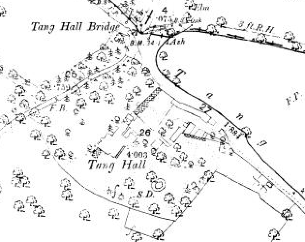
There are a couple of explanations for where the ‘Tang’ bit comes from: one, that it is from the word ‘tong’, referring to a place where two becks, or streams, meet, and the other, that it is related to the French ‘etang’ for pond. Both make sense given that two becks do indeed meet in Tang Hall, and there was a large pond roughly where Foss Islands Road is today. The ‘Hall’ part of the name comes from the fact that there was, in fact, a hall, the original ‘Tang Hall’, which is supposed to have stood on Fourth Avenue and is now flats.
Where *exactly* was this hall? I had to know.
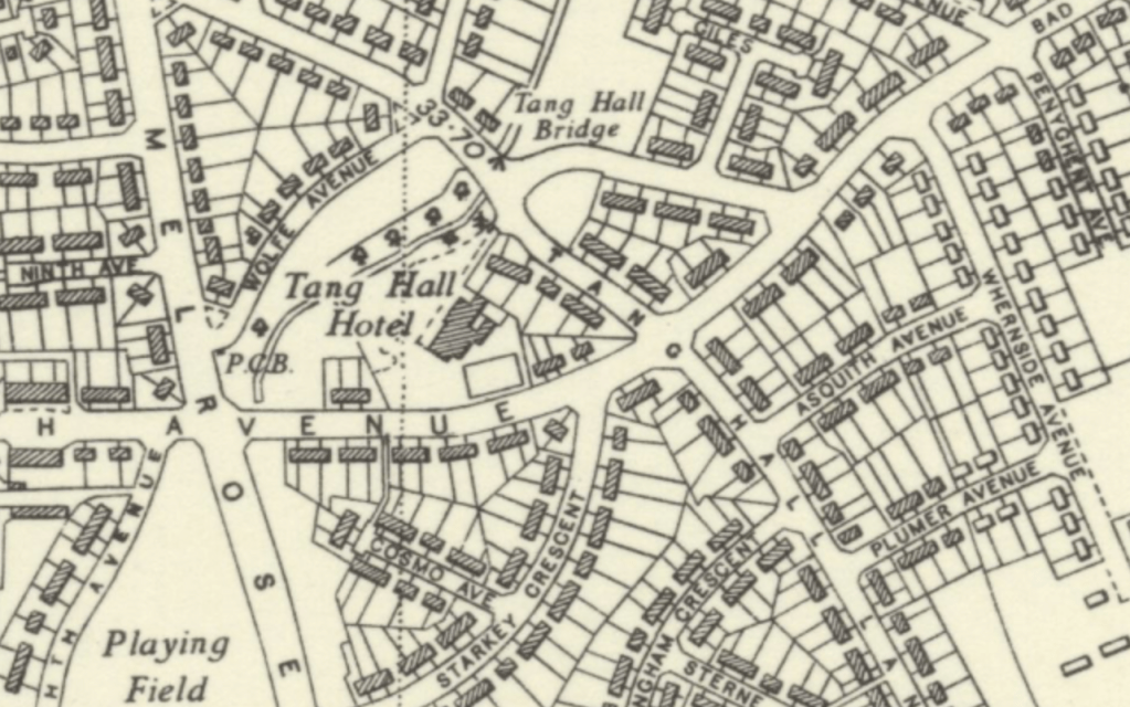
I walked down Fourth Avenue and noted where the flats were: there were a few possibilities. We turned to our trusty 1852 map of York – nothing, and the map cuts off partway down where Fourth Avenue would be. A search of some other OS maps, and a description from the City of York Council of development in the area, did the trick here, and I was convinced I had found where it was, purely to satisfy my own curiosity. (As it turns out, if I had just scrolled down a little further in the Council’s description of Tang Hall’s ‘character’, I would have found a map with the hall marked right on it, but digging like this was much more fun and much more satisfying, finding it without the help of the modern map.) The ‘character description’ mentioned a cul-de-sac and some recently-built flats which were in the area of the hall, and which were newer than the surrounding houses. The OS maps all showed the hall in close proximity to Tang Hall Lane, just south of a bridge, over the beck, and this, together, made it all make sense. (The hall became a hotel for a while, hence the name on one of the maps, and then it was a pub, and then it was demolished. A Starkey family lived in it for a time, and they have a road named for them just nearby).
The main, central, part of Tang Hall was built in the 1920s; the plan was to build houses that were healthy to live in compared to some of the urban housing and slums that existed at the time and were gradually being cleared away.
This journey into the history of Tang Hall was so interesting that I thought, ‘which part of York do I want to talk about next?’
The corner of York where the University now stands seemed an obvious choice, given I work there and was a student there. I’m talking about University of York, rather than York St John (although Archbishop Holgate’s School once stood roughly where YSJ is now, after it moved out of the cathedral close, so that’s a point for YSJ). The University of York stands right next to Heslington village, outside the city. There are two other parts of the campus: the east campus and King’s Manor. As far as I can tell, the east campus site was just…land prior to being built on; I remember when it was still very new, out there at the edge of the world. King’s Manor, in town, belonged to St Mary’s Abbey, then became the headquarters of Henry VIII’s Council of the North – Henry even stayed there on a progress to York – and was later a school for the blind, before becoming part of the university in the 1960s. Here, however, I want to focus on the main campus. Yes, I know technically we’re meant to call it Campus West, but to me it has always just been ‘the main campus’.
I was looking at the OS maps from 1853, 1910, 1931, 1948, and 1953; these all date from before the University was founded in 1963. I could see the usual sights: Heslington Hall, that beacon of ‘beautiful’ architecture amongst all that 60s brutalism; the church and the village, no lake because the lake that exists today isn’t natural…but there were some things that I did not expect to see.
There was a fishpond, and from 1910, a boathouse. There was a wood, ‘Spring Wood’, and a lane, the original Spring Lane: there is a building on campus now by that name.
Roughly where Wentworth College stands today, there was a bleach works. That disappears from the maps after 1853, since it was closed in the 1850s and the buildings demolished. There is, however, a Bleachfield House nearby on the 1910 map…
On the road that runs through campus and out to Heslington village, there was a spot marked ‘the site of the old hospital’, and then just south of Heslington Hall, a hospital. I couldn’t think what this hospital was, and what was this old hospital that used to exist where now stands a modern chemistry department building?
It turns out these are both the same institution, which moved to a different site. The original hospital was founded by one Sir Thomas Hesketh in 1608; he had bought the land to fund it, and set out the terms in his will, and then his widow actually had it built. This was not a hospital in the modern, medical, sense: this was a place where the elderly, the poor, and the infirm could go and live and be looked after. A lot of these were attached to religious houses prior to the Reformation, so many were shut down, but some still existed after the Reformation, as did almshouses, as places for the more vulnerable in society to live.
In 1795 the hospital moved to just south-west of Heslington Hall, rebuilt by one Henry Yarburgh, a member of the family who lived in Heslington Hall; he also, in the same year, gave the land for a school in Heslington, which still exists today. I’m not clear on what happened to the hospital, or whether it still houses eight poor people (Sir Thomas required that one be a woman, and that they all receive £5 each, worth about £600 today), but the building is still there, and looks like a little row of cottages, with an explanatory plaque above the door.
Heslington Hall is Elizabethan, built in the 1560s for Sir Thomas Eynns, the secretary to the Council of the North, although a lot of what we see now is actually nineteenth-century. It was taken over by the RAF during the Second World War; the Deramore family who lived there had evacuated and when they didn’t come back after the war, J. B. Morrell, a leading figure in the founding of the University of York (the university library is named after him) bought it in the 1950s, and now the University uses it for various offices and events.
Finally, one of the pubs in Heslington is called the Charles XII, and I have gone more than ten years not knowing why the pub is called this. Now I know. It is named after a horse that won a race in 1839; the horse belonged to the family who lived in Heslington Hall. It now occurs to me that there is, in fact, a picture of a horse outside the pub, which maybe should have been a clue…
Anyway, I hope you have enjoyed this trip through the edges of York, to Tang Hall, Heslington village, and the University of York. I hope it’s got you thinking: where did the name of your neighbourhood come from? Are there any visible clues as to what those familiar streets used to contain?
P.S. The market that started off this whole conversation about Tang Hall’s name is called Food Circle York. It is great; you should go to it if you live in York.
Further Reading
Probably the best old map of York that I know of: https://yorkmaps.net/1852/#17/53.9622/-1.0821
The 1852 map is my favourite, but these others are a very close second: https://maps.nls.uk/geo/find/#zoom=11&lat=53.93457&lon=-1.13553&layers=102&b=1&z=0&point=53.97134,-1.03391&i=100945724 and these: https://www.british-history.ac.uk/os-1-to-2500/york
For the character of Tang Hall, as described by the City of York Council: https://www.york.gov.uk/downloads/file/1154/area-56-tang-hall-estate (it is actually very informative)
For a more detailed history of Hesketh’s Hospital: https://www.british-history.ac.uk/vch/yorks/east/vol3/pp66-74
